


Hidaka Yabakei Area
Geological Site
D7
Former Plate Boundary at the Fuyushima Ooma
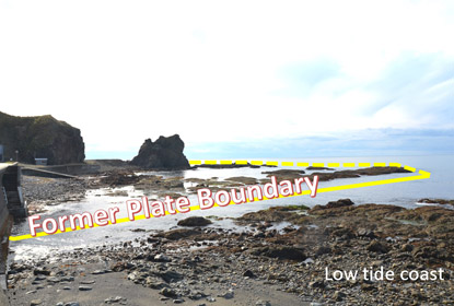
This is the former plate boundary where two continental plates collided and created the Hidaka Mountains, including Mt. Apoi. The Hidaka Mountain range to the east is layered with biotite gneiss and amphibolite rock from the former North American plate, and the metagabbro rock formations in the ocean to the west are from the former Eurasia plate.
These two completely different rocks are located here right next to each other. The former plate boundary is a large fault line that continues along the Hidaka Mountains running 140 km north to south. Such a sight is extremely rare above ground and is exceptionally valuable from an academic perspective.
Look to the cliff on the mountainside where you can see the waterfall. This is where the plate collision occurred. The fault line is flanked by different types of rock that have been eroded to create the waterfall.
On days when the tide is low, a deep trench in the coastline becomes exposed. This is the plate boundary. The fault line was eroded over time by the ocean waves and carved the deep trench. This area is called "Ooma" by the locals and kelp is harvested here.