


Hidaka Yabakei Area
Geological Site
D5
Geological fold at the Ruranbetsu Tunnel
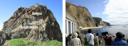
This large rock features slightly reddish-purple brown gneiss enclosing green-gray amphibolite in a geological structure called a fold. The immense mountain-forming power of the earth can easily bend hard rock.
Behind are vertical cliffs rising 100 meters called Hidaka Yabakei. This landform was created by the erosive force of waves, and is known as a sea cliff. A close look at the top of the cliffs shows a boundary between geological strata with gravel and other terrace deposits above it. This suggests that the top of the cliffs was also part of the shoreline hundreds of thousands of years ago and rose to this height as a result of ground uplift and sea-level change.
The Edo Shogunate built the Samani Mountain Path on the cliffs in 1799 to alleviate the difficulty of passing the Hidaka Mountains, which face the Pacific Ocean and divide Hokkaido into eastern and western parts. It is known as the first government-administered road in eastern Ezo, together with the Saruru Mountain Path built in Erimo Town.