

Blog
2025.08.01
Kamchatka Peninsula Earthquake and Tsunami - July 30
*This blog post is a brief report on the situation here in Samani.
Wednesday, August 30, 8:25 AM
A massive magnitude 8.8 earthquake struck off the southeastern coast of Russia's Kamchatka Peninsula, prompting the Japan Meteorological Agency to issue a tsunami warning along the entire Pacific coast, from Hokkaido to Wakayama prefecture.
The earthquake epicenter was located at a depth of 21.5 km (USGS).
9:40 AM
A tsunami warning was issued for the coastal areas along the Pacific Ocean, including Samani.
Evacuation orders issued for the following areas: Utoma, Nishimachi, Minatomachi, Honmachi, Sakaemachi, Kaishomachi, Odori, Nishikimachi, Midorimachi, Hirau, Fuyushima, Horoman, Asahi
Evacuation Centers: Hoyoji Temple, Sobiraso Retirement Home, Okada Community Center, Tashiro Research Center, Tojuin Temple, Sumiyoshi Shrine, Hokyoji Temple, Chikyoji Temple, Apoi Sanso, Asahi Community Center, Nishimachi Fire Department Construction Site Office
10 AM
Use of the Mt Apoi Foothill Family Campground, Oyakoiwa Fureai Beach Campgrounds was suspended due to the tsunami warning, and will only resume after the tsunami warning is lifted.
That evening
Overnight Evacuation Centers: Hoyoji Temple, Tojuin Temple, Sumiyoshi Shrine, Hokyoji Temple, Chikyoji Temple, Apoi Sanso
8:45 PM
The tsunami warning was downgraded to a tsunami advisory, and therefore, the evacuation orders issued for the town were lifted.
Thursday, July 31, 4:30 PM
The tsunami advisory was lifted.
The Mt. Apoi Foothill Family Campground and Oyakoiwa Fureai Beach Campground reopened.
----------
Observed Tsunami Height
Tsunami waves reached a wide area from Hokkaido to Okinawa.
- Kuji Port, Iwate 1m30cm
- Tokachi Port in Hiroo, Hokkaido: 70 cm at 1:18 PM on July 31. The first wave was recorded at 10:32 AM on July 30.
- Shoya, Erimo, Hokkaido: 60cm at 9:14 PM on July 30
- Urakawa, Hokkaido: 20cm at 4:06 PM on July 30. Unable to determine when the first wave occurred.
https://www.jma.go.jp/bosai/map.html#6/40.772/144.492/&elem=info&contents=tsunami
----------
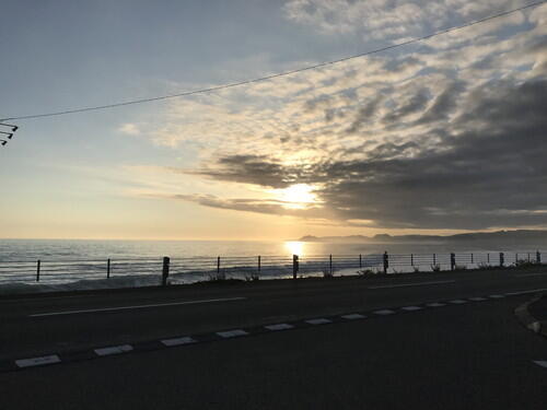
Weather Conditions
At the observation site in neighboring Urakawa, the high temperature was 25.7 degrees Celsius and the low temperature was 20.4 degrees Celsius.
The weather was cloudy with some sunny intervals. Humidity was around 83-100%.
----------
The Earthquake
▼Reference: https://scienceportal.jst.go.jp/gateway/clip/20250731_g01/index.html
The Kamchatka Peninsula, where the massive earthquake occurred, is located where the Pacific Plate on the ocean side is subducting beneath the North American Plate on the land side. This earthquake is the same trench-type earthquake that caused the 2011 Tohoku-Pacific Ocean Earthquake, which triggered the Great East Japan Earthquake and Tsunami.
According to the US Geological Survey (USGS), the Pacific Plate is slowly moving northwestward at a rate of 80 mm per year relative to the North American Plate in this area. This massive earthquake was a reverse fault earthquake caused by pressure building up in the northwest direction and then rebounding.
The USGS has stated that this massive earthquake is the largest in the world since the Tohoku Pacific Ocean Earthquake, and ranks among the top 10 largest earthquakes to occur worldwide since 1900. Before this earthquake, there were 50 earthquakes with a magnitude of 5.0 or higher, including a magnitude 7.4 earthquake on July 20 and three magnitude 6.6 earthquakes.
----------
Warnings
Residents and visitors were continuously warned to stay away from rivers and coastlines, and to evacuate to higher ground until the tsunami warning was lifted. These warnings were also posted on road information signs along the road.
----------
Road Closures and Restrictions
▼ Expressways
E5 Hokkaido Expressway (Onuma Koen IC to Tomakomai Chuo IC)
E5 Hokkaido Expressway (Tomakomai Chuo IC to Chitose IC)
E63 Hidaka Expressway (Tomakomai Higashi IC to Numanoe-nishi)
▼ National Roads
There were some traffic restrictions in place.
Those who could not pass through Kogane Road had to take a detour via the Tenma Kaido. Between Samani and Urakawa, there were some restrictions on the coastal national highway, but some people took the detour through the mountains.
----------
Previous Tsunami at Kamchatka Peninsula
- 1952 Kamchatka Peninsula Earthquake
- Occurred at 1.58 AM on November 5
- 2 magnitude (Earthquake Observatory)
- The earthquake was felt in several locations along the Pacific coast from Nemuro to Hitachi. Two to five hours after the earthquake, 1-2 meter high tsunami waves struck along the coasts of Hokkaido and Honshu, coinciding with high tide at 5 PM and causing minor damage.
- The tsunami was larger along the Sanriku coast than in Hokkaido. In Hokkaido, a tsunami of up to 1 meter hit the coast, causing flooding in low-lying areas and damaging houses in Hamanamura Kiritaka, Kushiro, Hakodate, and other areas. Along the Sanriku coast, the tsunami was larger than that caused by the Tokachi-oki earthquake on March 4, 1952, reaching wave heights of 1 to 3 meters. As a result, houses were flooded, fields were submerged, and port facilities, as well as seaweed and oyster farming facilities, fishing boats, and fishing gear, were damaged or lost.