

Blog
2022.03.09
Record of Samani Disasters and Ainu Legends
The day after tomorrow is March 11th, the anniversary of the Great East Japan Earthquake. So I would like to write down what was covered during a "Hometown and Geo-study" lecture held on March 6, 2019.
Erimo Shrine "Earthquake Uminari-sora Tsunami" Stone Monument
Two monuments were erected in Erimo using donations from the 1933 Sanriku Earthquake and Tsunami. These monuments can be found in front of the Erimo Shrine and Shoya Police Station and convey the horror of the tsunami and earthquake to future generations. These two monuments are indicated by the "Natural Disaster Monument" map symbol on the when looking on the maps on the Geospatial Information Authority of Japan's website.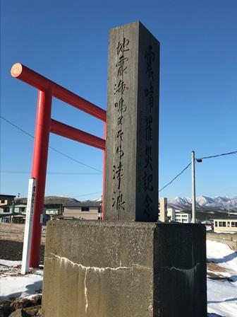
Samani Ainu Legends: Samatki Whale Bone and Tsunami
There is a series of mountain peaks that form a long line between the Shintomi district of Samani to the Kamikineusu area of neighboring Urakawa, and several of these peaks reach 600 to 700 meters in height. These mountains were called Samatki, which in Ainu means to lie down. It's said that the bones of a whale lay on the top of this mountain. There is also a story from long ago that says a whale was once washed ashore by a tsunami, and there are many people who claim to have seen the whale bones (Mt. Apoi Geopark Guidebook).
Record of Samani Disasters and Regional Tsunamis: 4 Tsunamis along the Sanriku Coast
1. August 23, 1856, Eastern Michinoku
- Magnitude 7.7 earthquake, tsunami struck Hidaka, Iburi, Oshima
- Landslides near Erimo (Usami, 2003)
- Two ships that weighed more than 500 stones were overturned near Urakawa (1 stone = 150kg, 500 stones=75 tons) (Musha, 1951)
2. June 15, 1896, Sanriku Earthquake and Tsunami
- Magnitude 8.2 earthquake occurred at 7:32 AM
- Tsunami struck the Sanriku coast 30 minutes later
- 22,000 people died from Miyagi prefecture to Hokkaido due to the earthquake and tsunami.
- No casualties in Samani from the tsunami, 6 died in Erimo due to collapsing homes (Kagami, 2006)
The tsunami in Erimo reached a height of 4 meters (Usami, 2003)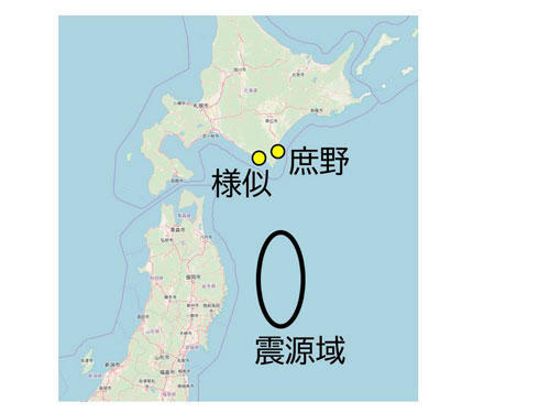
様似 = Samani, 庶野 = Shoya, 震源域 = Source of Earthquake
3. March 3, 1933 Sanriku (Showa Sanriku Earthquake)
- 37 years after the 1896 Sanriku earthquake, a magnitude 8.1 occurred at 2:30 AM.
- The tsunami struck the coast 30-60 minutes after the earthquake,
- 1 dead in Urakawa and Samani and 12 in Erimo, caused by houses and fishing boats being washed away, flooding, and debris. (Nasu/Takahashi 1933)
- 10 dead in Minomura Village and 3 in Kogoshi Village (current Erimo) (Central Meteorological Observatory, 1933)
- Three tsunami waves struck in intervals of 30 minutes after the earthquake. The third wave was 14.2 m, and left 13 dead, 56 injured, and 90 collapsed homes and buildings. The damage was estimated at 340,000 JPY (current prices around 2 trillion JPY) (Erimo Town Folk Museum)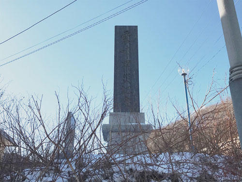
Shoya district monument in Erimo
4. Damage caused by the Great East Japan Earthquake in 2011
The Great East Japan tsunami that occurred on March 11, 2011 was also caused by an earthquake whose epicenter was near the Japan Trench off Sanriku, in the Pacific Ocean. At that time, the seismic intensity that Samani experienced was recorded as a Shindo 4 on the Shindo Scale, which was not very large. Afterward, several tsunami waves exceeding 3 meters flooded Samani. Fortunately, there was no casualties or injuries, but the damage was estimated at over 700 million yen. Damage included flooded homes, sunk fishing boats, and damage to fish processing facilities.
Follow the link for photos:
https://www.apoi-geopark.jp/other/column.html
It's important to know the historical records. I don't believe it's widely known that there were human casualties caused by past tsunamis in Samani and the surrounding towns. Also, please let us know if you have seen photographs that show old terrain (especially the coastline) and tsunami deposits of sand at the base of trees. Knowing the tsunami deposits will lead to understanding the records of past tsunamis.