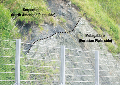
The Hidaka Mountains, including Mt. Apoi, formed when the edge of one plate was thrust on top of another as they collided. The plate boundary here is called the Hidaka Main Thrust (HMT).
This boundary is a large fault extending approximately 140 km from north to south along the Hidaka Mountains. It is academically significant because there are few places where such a boundary is visible above the ground. For this reason, the outcrop here is shown without cover in an area where disaster prevention work has been implemented everywhere due to the extensive precipitous cliffs. The upper-left black part of the outcrop is serpentinite (metamorphosed peridotite) on the North American Plate side, whereas the lower-right greenish part is metagabbro (metamorphosed gabbro) on the Eurasian Plate side. Thus, the area to the east of here features the geology of the Hidaka Mountains (previously on the North American Plate side).
Visitors to this geosite should be careful to passing vehicles, as it is located on the shoulder of a national highway.


